
|
|
|
 |
 |
|
|
|
|
|
|
|
||||
| Number | Name | Intensity | Centre In-charge | Provided Information |
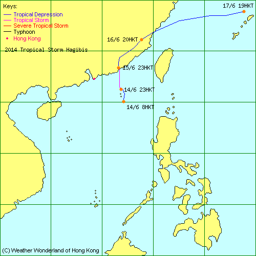
| 2014-07W | Hagibis | L.P. | JTWC | Track Data | Weather Observation | Warnings |
| Track Map | ||||
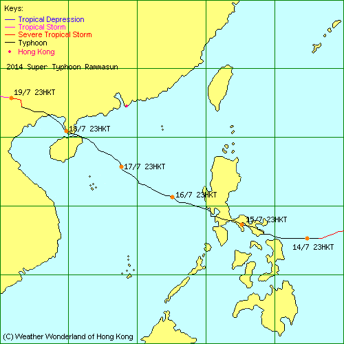
| 2014-09W | Rammasun | L.P. | HKO | Track Data | Weather Observation | Warnings |
| Track Map | ||||
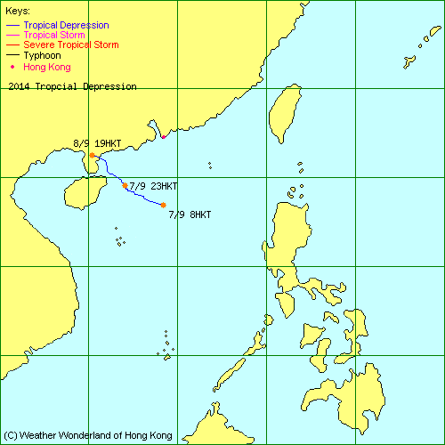
| 2014-14W | - | L.P. | HKO | Track Data | Weather Observation | Warnings |
| Track Map | ||||
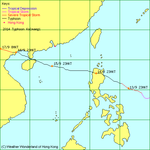
| 2014-15W | Kalmaegi | L.P. | HKO | Track Data | Weather Observation | Warnings |
| Track Map | ||||
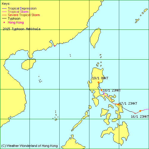
| 2015-01W | Mekkhala | L.P. | HKO | Track Data | Track Map |
| 2015-02W | Higos | L.P. | JTWC | Track Data |
| 2015-03W | Bavi | L.P. | HKO | Track Data |
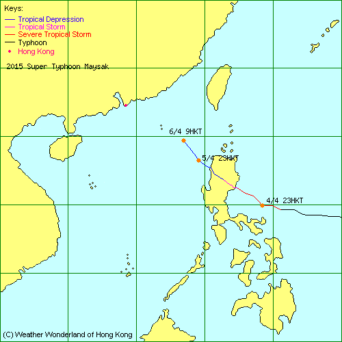
| 2015-04W | Maysak | L.P. | HKO | Track Data | Track Map |
| 2015-05W | Haishen | L.P. | JTWC | Track Data |
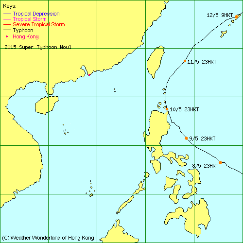
| 2015-06W | Noul | L.P. | HKO | Track Data | Track Map |
| 2015-07W | Dolphin | L.P. | JTWC | Track Data |
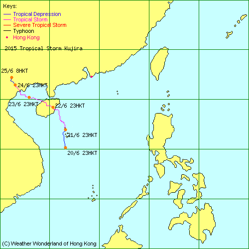
| 2015-08W | Kujira | L.P. | HKO | Track Data | Weather Observation | Warnings |
| Track Map | ||||
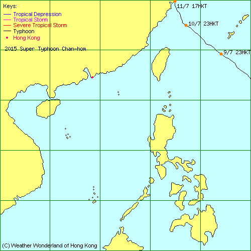
| 2015-09W | Chan-hom | L.P. | JTWC | Track Data | Track Map |
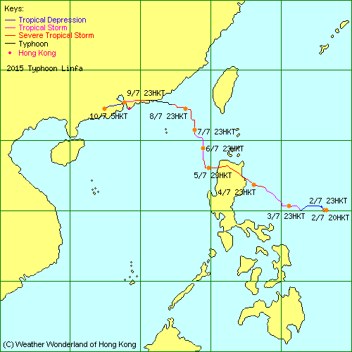
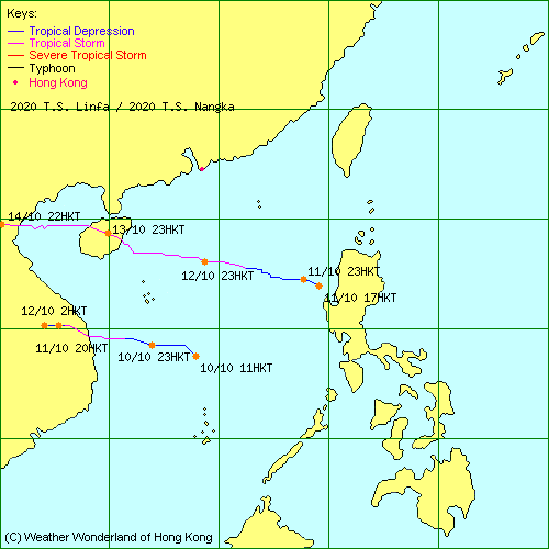
| 2015-10W | Linfa | L.P. | HKO | Track Data | Weather Observation | Warnings |
| Track Map | ||||
| 2015-11W | Nangka | L.P. | JTWC | Track Data |
| 2015-01C | Halola | L.P. | HKO | Track Data |
| 2015-12W | - | L.P. | JTWC | Track Data |
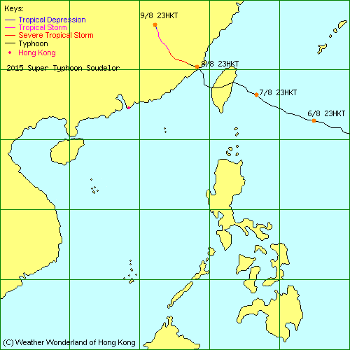
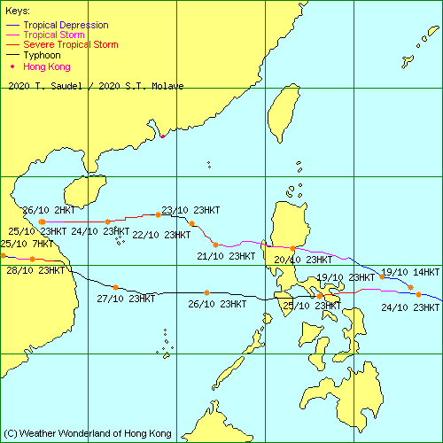
| 2015-13W | Soudelor | L.P. | HKO | Track Data | Track Map |
| 2015-14W | - | L.P. | JTWC | Track Data |
| 2015-15W | Molave | L.P. | JTWC | Track Data |
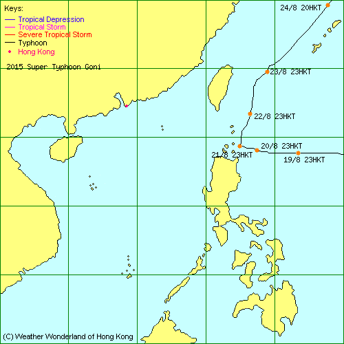
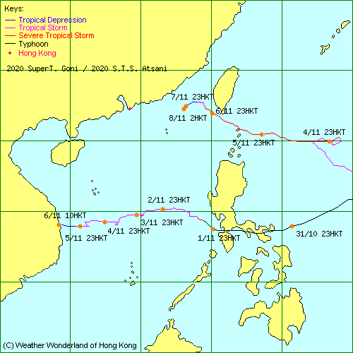
| 2015-16W | Goni | L.P. | JTWC | Track Data | Track Map |
| 2015-17W | Atsani | L.P. | JTWC | Track Data |
| 2015-03C | Kilo | L.P. | JTWC | Track Data |
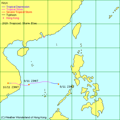
| 2015-18W | Etau | L.P. | JTWC | Track Data |
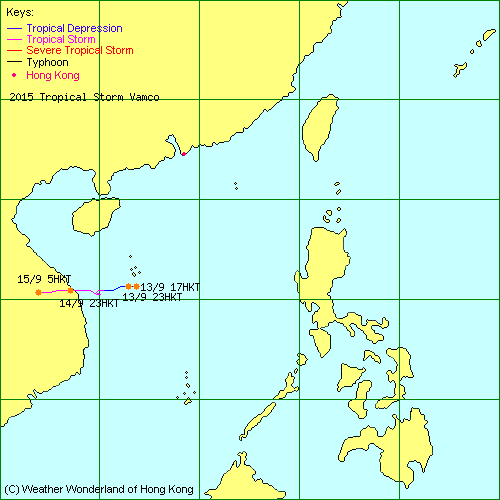
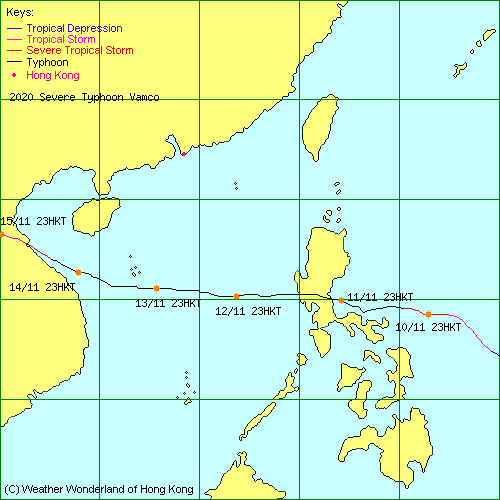
| 2015-19W | Vamco | L.P. | HKO | Track Data | Track Map |
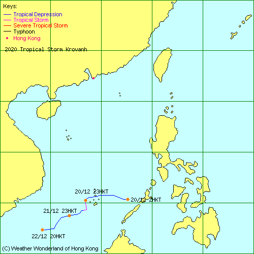
| 2015-20W | Krovanh | L.P. | JTWC | Track Data |
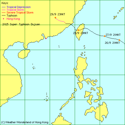
| 2015-21W | Dujuan | L.P. | HKO | Track Data | Track Map |
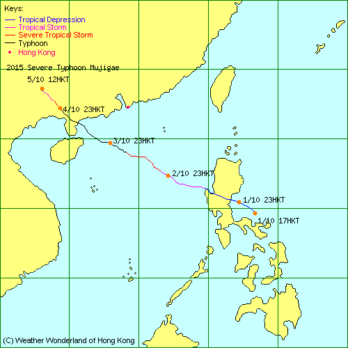
| 2015-22W | Mujigae | L.P. | HKO | Track Data | Weather Observation | Warnings |
| Track Map | ||||
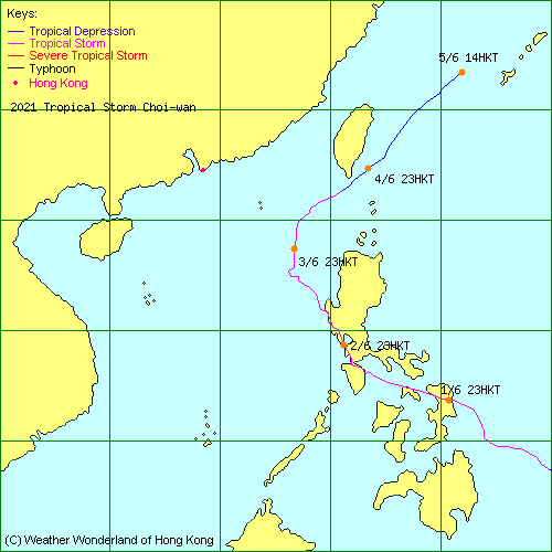
| 2015-23W | Choi-wan | L.P. | JTWC | Track Data |
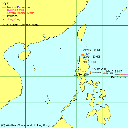
| 2015-24W | Koppu | L.P. | HKO | Track Data | Track Map |
| 2015-25W | Champi | L.P. | JTWC | Track Data |
| 2015-26W | - | L.P. | JTWC | Track Data |
| 2015-27W | In-fa | L.P. | HKO | Track Data |
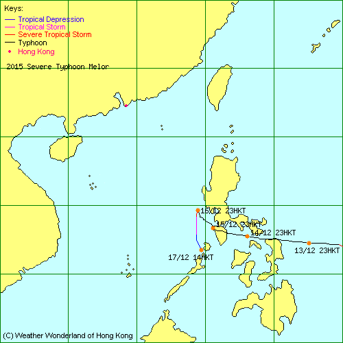
| 2015-28W | Melor | L.P. | HKO | Track Data | Track Map |
| 2015-29W | - | L.P. | JTWC | Track Data |
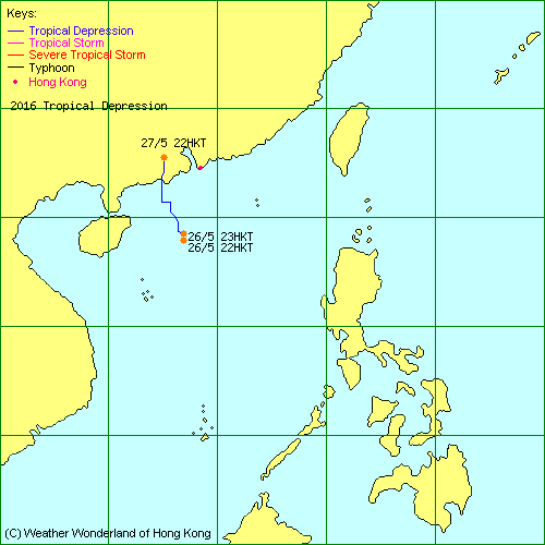
| 2016-01W | - | L.P. | HKO | Track Data | Weather Observation | Warnings |
| Track Map | ||||
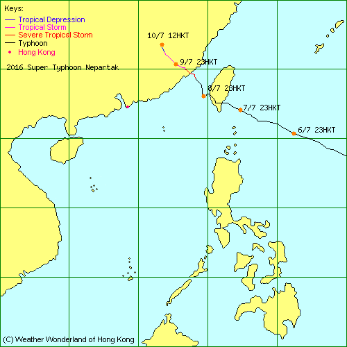
| 2016-02W | Nepartak | L.P. | HKO | Track Data | Track Map |
| 2016-03W | - | L.P. | JTWC | Track Data |
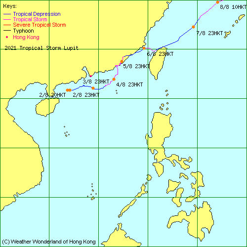
| 2016-04W | Lupit | L.P. | JTWC | Track Data |
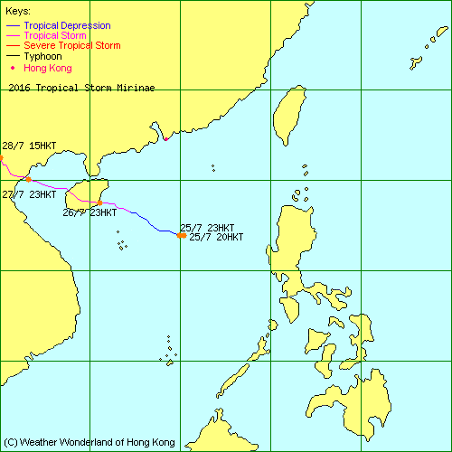
| 2016-05W | Mirinae | L.P. | HKO | Track Data | Weather Observation | Warnings |
| Track Map | ||||
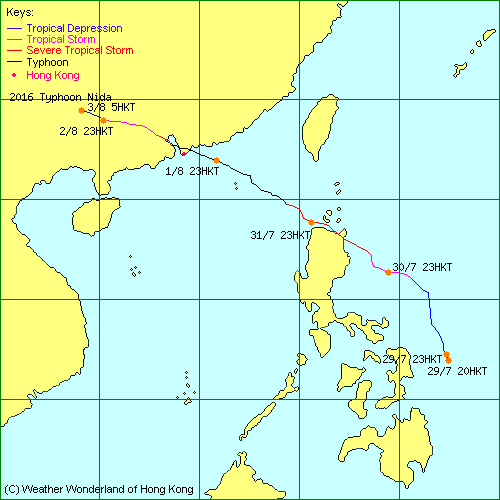
| 2016-06W | Nida | L.P. | HKO | Track Data | Weather Observation | Warnings |
| Track Map | ||||
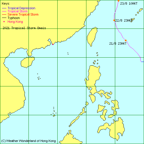
| 2016-07W | Omais | L.P. | JTWC | Track Data |
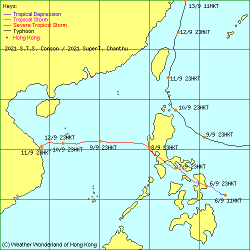
| 2016-08W | Conson | L.P. | JTWC | Track Data |
| 2016-09W | Chanthu | L.P. | JTWC | Track Data |
| 2016-10W | Mindulle | L.P. | JTWC | Track Data |
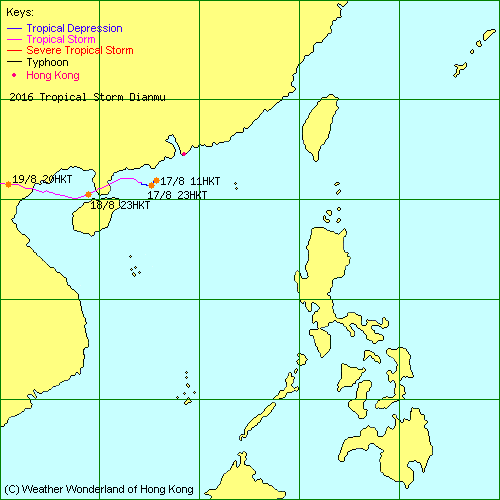
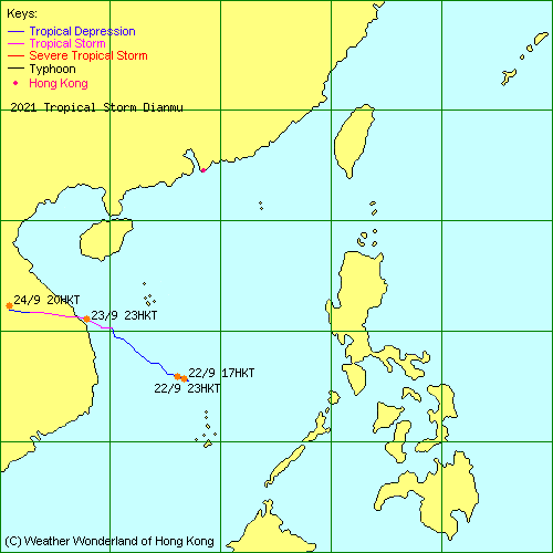
| 2016-11W | Dianmu | L.P. | HKO | Track Data | Weather Observation | Warnings |
| Track Map | ||||
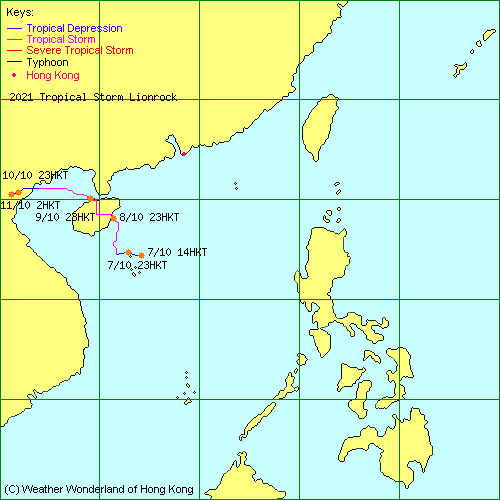
| 2016-12W | Lionrock | L.P. | JTWC | Track Data |
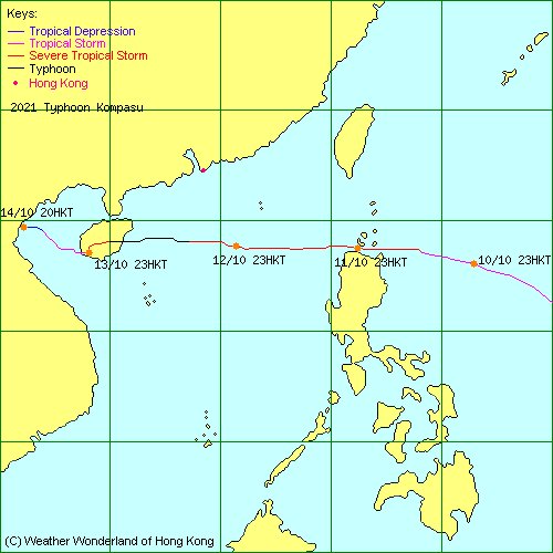
| 2016-13W | Kompasu | L.P. | JTWC | Track Data |
| 2016-14W | - | L.P. | JTWC | Track Data |
| 2016-15W | Namtheun | L.P. | HKO | Track Data |
| - | Malou | L.P. | HKO | Track Data |
| 2016-16W | Meranti | L.P. | HKO | Track Data | Weather Observation | Warnings |
| Track Map | ||||
| 2016-17W | - | L.P. | JTWC | Track Data |
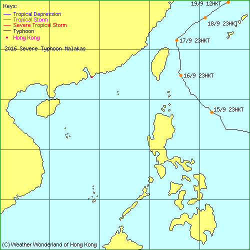
| 2016-18W | Malakas | L.P. | JTWC | Track Data | Track Map |
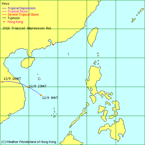
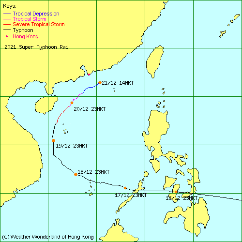
| 2016-19W | Rai | L.P. | HKO | Track Data | Track Map |
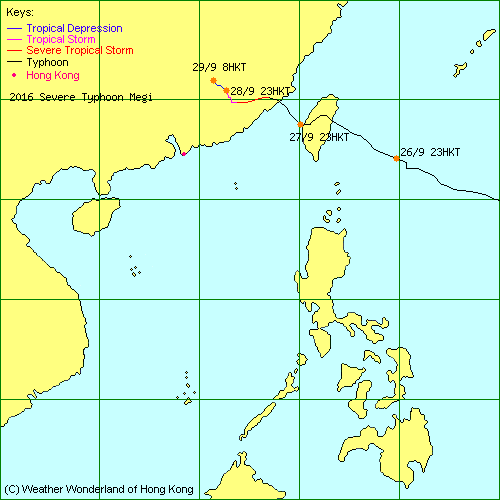
| 2016-20W | Megi | L.P. | HKO | Track Data | Weather Observation | Warnings |
| Track Map | ||||
| 2016-21W | Chaba | L.P. | HKO | Track Data |
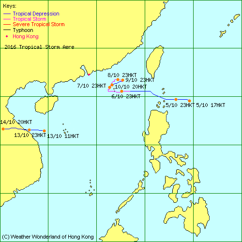
| 2016-22W | Aere | L.P. | HKO | Track Data | Weather Observation | Warnings |
| Track Map | ||||
| 2016-23W | Songda | L.P. | JTWC | Track Data |
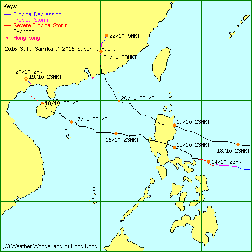
| 2016-24W | Sarika | L.P. | HKO | Track Data | Weather Observation | Warnings |
| Track Map | ||||
| 2016-25W | Haima | L.P. | HKO | Track Data | Weather Observation | Warnings |
| Track Map | ||||
| 2016-26W | Meari | L.P. | JTWC | Track Data |
| 2016-27W | Ma-on | L.P. | JTWC | Track Data |
| 2016-28W | - | L.P. | JTWC | Track Data |
| 2016-29W | Tokage | L.P. | HKO | Track Data | Track Map |
| - | - | L.P. | HKO | Track Data | Track Map |
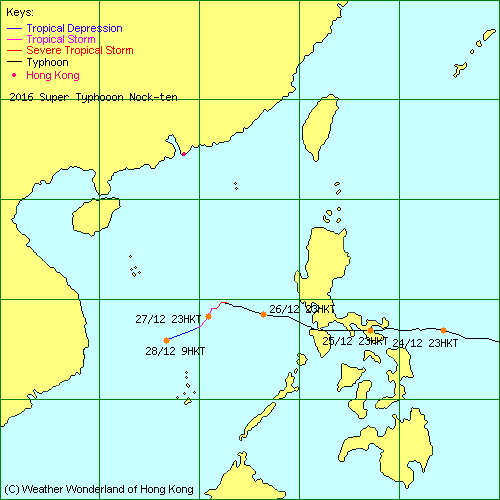
| 2016-30W | Nock-ten | L.P. | HKO | Track Data | Track Map |
| 2017-01W | - | L.P. | JTWC | Track Data | Track Map |
| 2017-02W | - | L.P. | HKO | Track Data | Track Map |
| 2017-03W | Muifa | L.P. | HKO | Track Data |
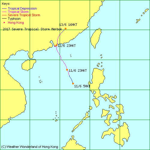
| 2017-04W | Merbok | L.P. | HKO | Track Data | Weather Observation | Warnings |
| Track Map | ||||
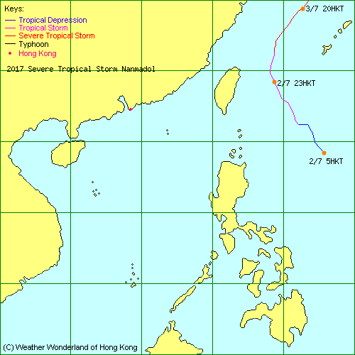
| 2017-05W | Nanmadol | L.P. | JTWC | Track Data | Track Map |
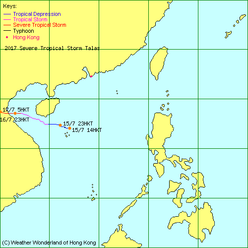
| 2017-06W | Talas | L.P. | HKO | Track Data | Track Map |
| 2017-07W | Noru | L.P. | JTWC | Track Data |
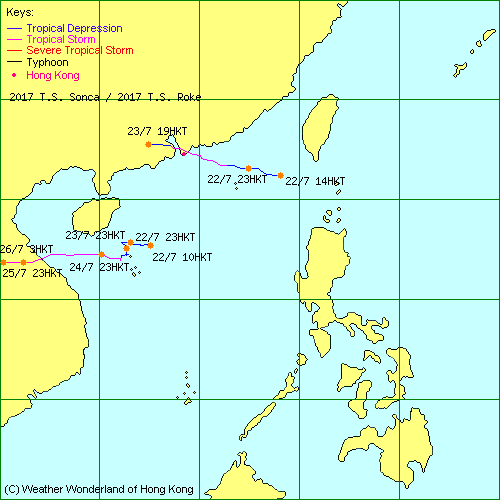
| 2017-08W | Sonca | L.P. | HKO | Track Data | Track Map |
| 2017-09W | Kulap | L.P. | JTWC | Track Data |
| 2017-10W | Roke | L.P. | HKO | Track Data | Weather Observation | Warnings |
| Track Map | ||||
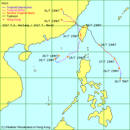
| 2017-11W | Nesat | L.P. | HKO | Track Data | Track Map |
| 2017-12W | Haitang | L.P. | HKO | Track Data | Track Map |
| 2017-13W | Nalgae | L.P. | JTWC | Track Data |
| 2017-14W | Banyan | L.P. | JTWC | Track Data |
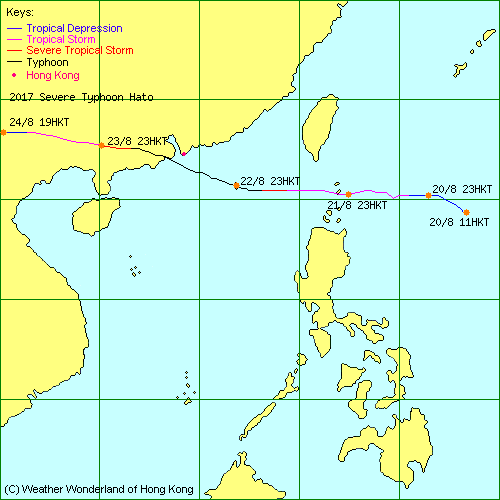
| 2017-15W | Hato | L.P. | HKO | Track Data | Weather Observation | Warnings |
| Track Map | ||||
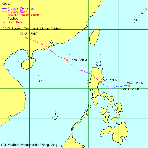
| 2017-16W | Pakhar | L.P. | HKO | Track Data | Weather Observation | Warnings |
| Track Map | ||||
| 2017-17W | Sanvu | L.P. | JTWC | Track Data |
| 2017-18W | Mawar | L.P. | HKO | Track Data | Weather Observation | Warnings |
| Track Map | ||||
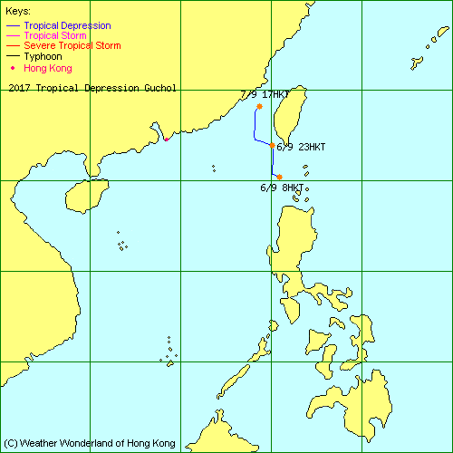
| 2017-19W | Guchol | L.P. | HKO | Track Data | Track Map |
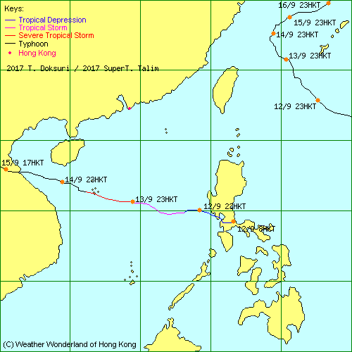
| 2017-20W | Talim | L.P. | JTWC | Track Data | Track Map |
| 2017-21W | Doksuri | L.P. | HKO | Track Data | Track Map |
| 2017-22W | - | L.P. | HKO | Track Data | Weather Observation | Warnings |
| Track Map | ||||
| 2017-23W | - | L.P. | HKO | Track Data | Track Map |
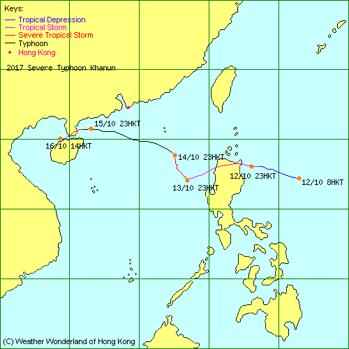
| 2017-24W | Khanun | L.P. | HKO | Track Data | Weather Observation | Warnings |
| Track Map | ||||
| 2017-25W | Lan | L.P. | JTWC | Track Data |
| 2017-26W | - | L.P. | JTWC | Track Data |
| 2017-27W | Saola | L.P. | HKO | Track Data |
| - | - | L.P. | HKO | Track Data |
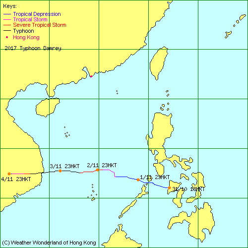
| 2017-28W | Damrey | L.P. | HKO | Track Data | Track Map |
| 2017-29W | - | L.P. | JTWC | Track Data |
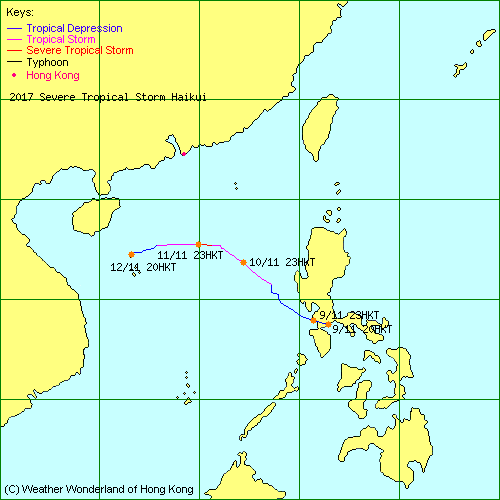
| 2017-30W | Haikui | L.P. | HKO | Track Data | Track Map |
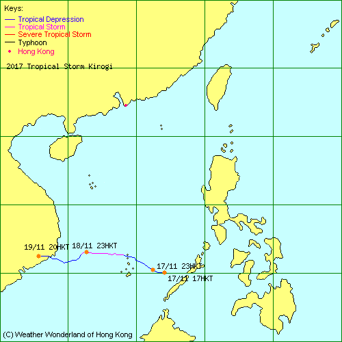
| 2017-31W | Kirogi | L.P. | HKO | Track Data | Track Map |
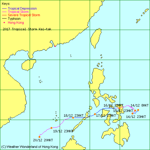
| 2017-32W | Kai-tak | L.P. | JTWC | Track Data | Track Map |
| 2017-33W | Tembin | L.P. | JTWC | Track Data |
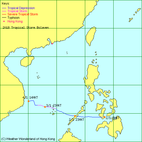
| 2018-01W | Bolaven | L.P. | HKO | Track Data | Track Map |
| 2018-02W | Sanba | L.P. | HKO | Track Data |
| 2018-03W | Jelawat | L.P. | JTWC | Track Data |
| 2018-04W | - | L.P. | JTWC | Track Data |
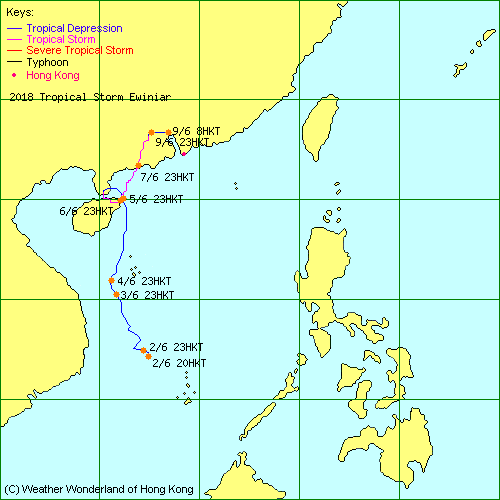
| 2018-05W | Ewiniar | L.P. | HKO | Track Data | Weather Observation | Warnings |
| Track Map | ||||
| 2018-06W | Maliksi | L.P. | JTWC | Track Data |
| 2018-07W | - | L.P. | JTWC | Track Data |
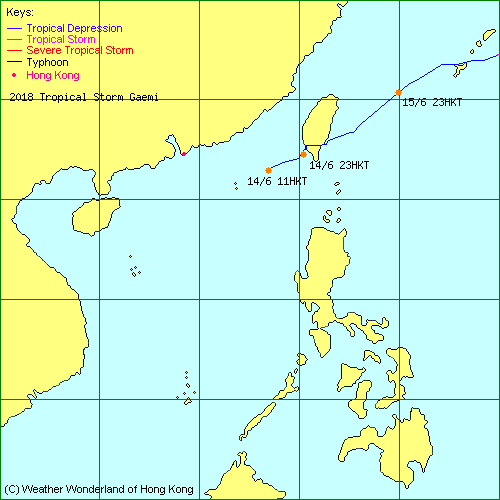
| 2018-08W | Gaemi | L.P. | HKO | Track Data | Track Map |
| 2018-09W | Prapiroon | L.P. | JTWC | Track Data |
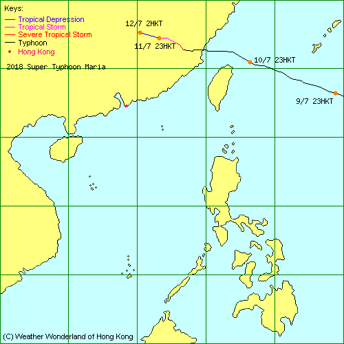
| 2018-10W | Maria | L.P. | HKO | Track Data | Track Map |
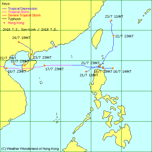
| 2018-11W | Son-tinh | L.P. | HKO | Track Data | Weather Observation | Warnings |
| Track Map | ||||
| 2018-12W | Ampil | L.P. | JTWC | Track Data |
| 2018-13W | - | L.P. | JTWC | Track Data | Track Map |
| 2018-14W | Wukong | L.P. | JTWC | Track Data |
| 2018-15W | Jongdari | L.P. | HKO | Track Data |
| 2018-16W | - | L.P. | JTWC | Track Data |
| 2018-17W | Shanshan | L.P. | JTWC | Track Data |
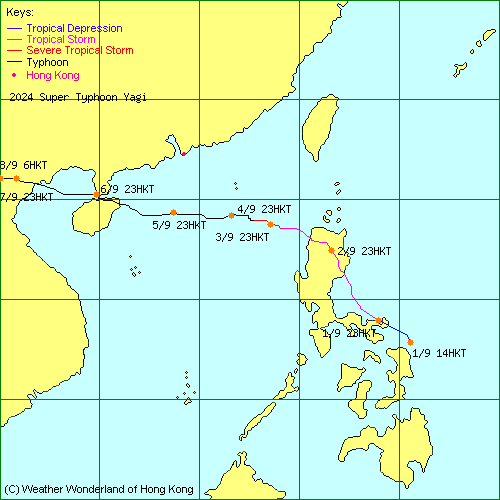
| 2018-18W | Yagi | L.P. | JTWC | Track Data | Track Map |
| 2018-19W | Leepi | L.P. | JTWC | Track Data |
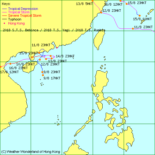
| 2018-20W | Bebinca | L.P. | HKO | Track Data | Weather Observation | Warnings |
| Track Map | ||||
| 2018-10E | Hector | L.P. | JTWC | Track Data |
| 2018-21W | Rumbia | L.P. | HKO | Track Data | Track Map |
| 2018-22W | Soulik | L.P. | JTWC | Track Data |
| 2018-23W | Cimaron | L.P. | JTWC | Track Data |
| 2018-24W | - | L.P. | HKO | Track Data | Track Map |
| 2018-25W | Jebi | L.P. | JTWC | Track Data |
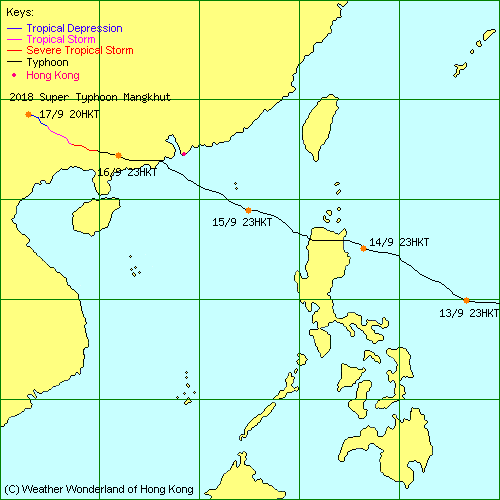
| 2018-26W | Mangkhut | L.P. | HKO | Track Data | Weather Observation | Warnings |
| Track Map | ||||
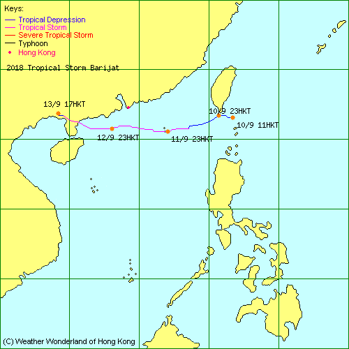
| 2018-27W | Barijat | L.P. | JTWC | Track Data | Weather Observation | Warnings |
| Track Map | ||||
| 2018-28W | Trami | L.P. | HKO | Track Data |
| 2018-29W | - | L.P. | JTWC | Track Data |
| 2018-30W | Kong-rey | L.P. | JTWC | Track Data |
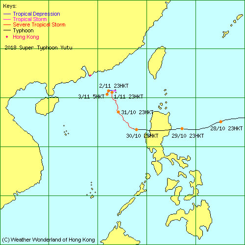
| 2018-31W | Yutu | L.P. | HKO | Track Data | Weather Observation | Warnings |
| Track Map | ||||
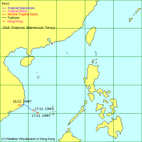
| 2018-32W | Toraji | L.P. | JTWC | Track Data | Track Map |
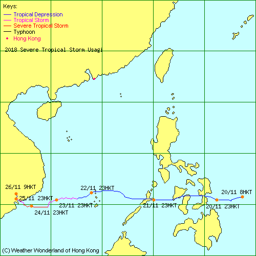
| 2018-33W | Usagi | L.P. | HKO | Track Data | Track Map |
| 2018-34W | Man-yi | L.P. | JTWC | Track Data |
| 2018-35W | - | L.P. | HKO | Track Data | Track Map |
| 2018-36W | Pabuk | L.P. | JTWC | Track Data |
| 2019-01W | - | L.P. | JTWC | Track Data |
| 2019-02W | Wutip | L.P. | JTWC | Track Data |
| 2019-03W | - | L.P. | JTWC | Track Data |
| - | Sepat | L.P. | HKO | Track Data |
| 2019-04W | - | L.P. | JTWC | Track Data |
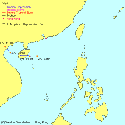
| 2019-05W | Mun | L.P. | HKO | Track Data | Weather Observation | Warnings |
| Track Map | ||||
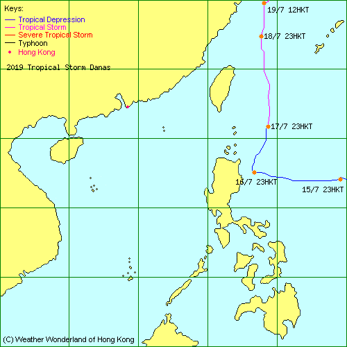
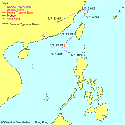
| 2019-06W | Danas | L.P. | HKO | Track Data | Track Map |
| 2019-07W | Nari | L.P. | HKO | Track Data |
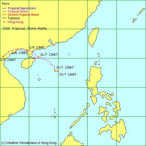
| 2019-08W | Wipha | L.P. | HKO | Track Data | Weather Observation | Warnings |
| Track Map | ||||
| 2019-09W | Francisco | L.P. | JTWC | Track Data |
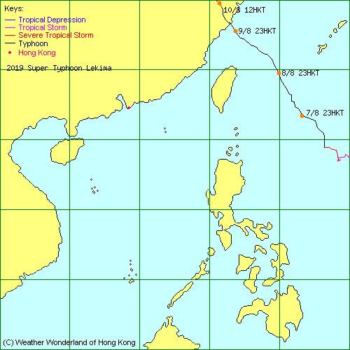
| 2019-10W | Lekima | L.P. | JTWC | Track Data | Track Map |
| 2019-11W | Krosa | L.P. | JTWC | Track Data |
| 2019-12W | Bailu | L.P. | HKO | Track Data | Weather Observation | Warnings |
| Track Map | ||||
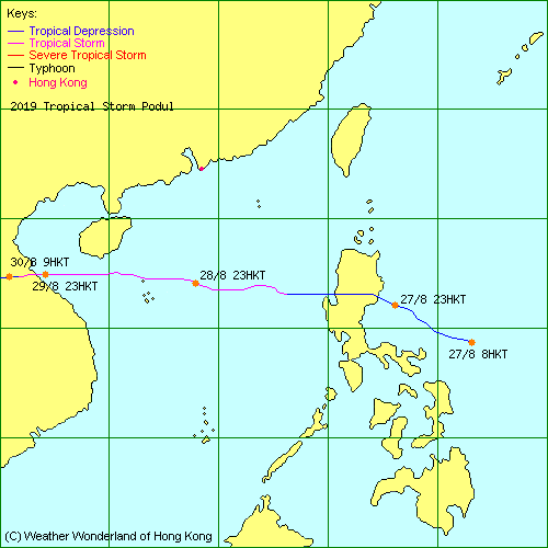
| 2019-13W | Podul | L.P. | HKO | Track Data | Weather Observation | Warnings |
| Track Map | ||||
| 2019-14W | Faxai | L.P. | JTWC | Track Data |
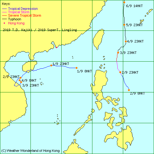
| 2019-15W | Lingling | L.P. | JTWC | Track Data | Track Map |
| 2019-16W | Kajiki | L.P. | HKO | Track Data | Weather Observation | Warnings |
| Track Map | ||||
| 2019-17W | Peipah | L.P. | JTWC | Track Data |
| 2019-18W | Tapah | L.P. | JTWC | Track Data |
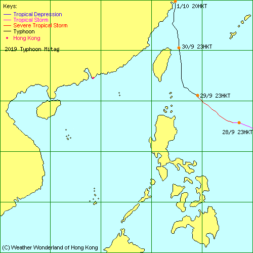
| 2019-19W | Mitag | L.P. | JTWC | Track Data | Track Map |
| 2019-20W | Hagibis | L.P. | JTWC | Track Data |
| 2019-21W | Neoguri | L.P. | JTWC | Track Data |
| 2019-22W | Bualoi | L.P. | JTWC | Track Data |
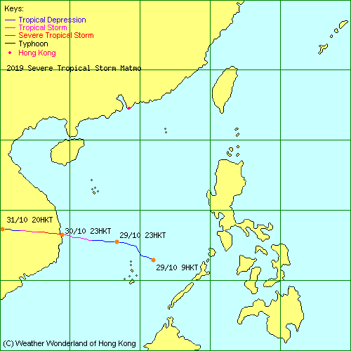
| 2019-23W | Matmo | L.P. | HKO | Track Data | Track Map |
| 2019-24W | Halong | L.P. | JTWC | Track Data |
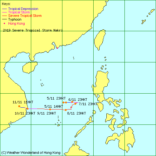
| 2019-25W | Nakri | L.P. | HKO | Track Data | Track Map |
| 2019-26W | Fengshen | L.P. | JTWC | Track Data |
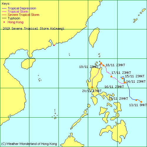
| 2019-27W | Kalmaegi | L.P. | JTWC | Track Data | Track Map |
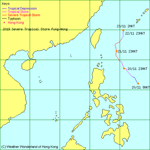
| 2019-28W | Fung-Wong | L.P. | JTWC | Track Data | Track Map |
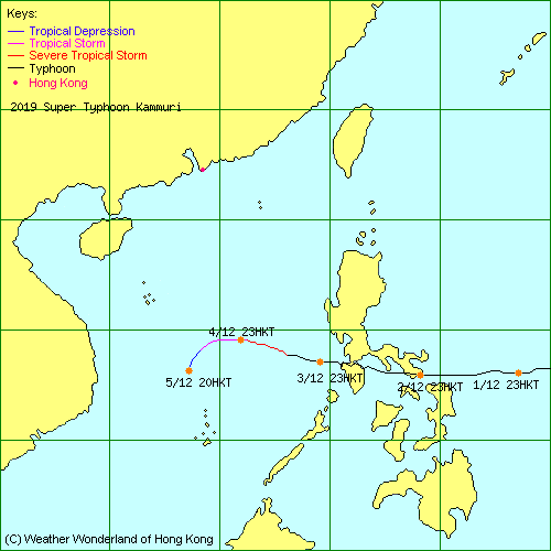
| 2019-29W | Kammuri | L.P. | JTWC | Track Data | Track Map |
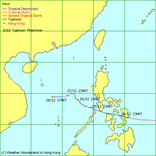
| 2019-30W | Phanfone | L.P. | JTWC | Track Data | Track Map |
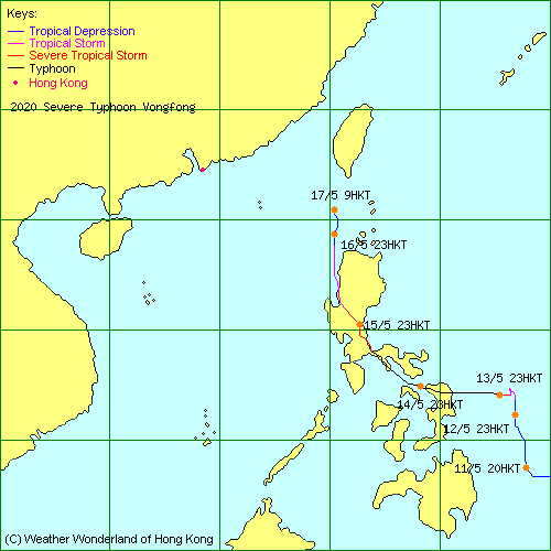
| 2020-01W | Vongfong | L.P. | HKO | Track Data | Track Map |
| 2020-02W | Nuri | L.P. | HKO | Track Data | Weather Observation | Warnings |
| Track Map | ||||
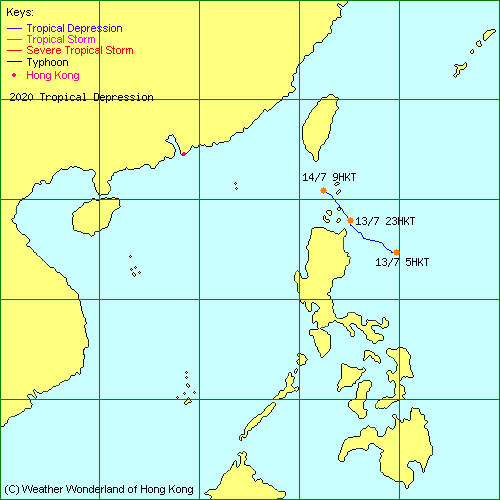
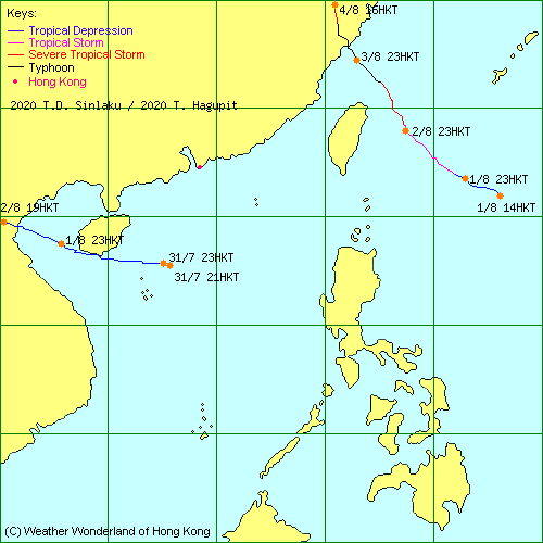
| - | - | L.P. | HKO | Track Data | Track Map |
| 2020-03W | Hagupit | L.P. | HKO | Track Data | Track Map |
| 2020-04W | Sinlaku | L.P. | HKO | Track Data | Weather Observation | Warnings |
| Track Map | ||||
| 2020-05W | Jangmi | L.P. | JTWC | Track Data |
| 2020-06W | - | L.P. | HKO | Track Data |
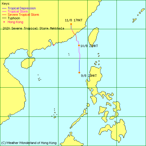
| 2020-07W | Mekkhala | L.P. | HKO | Track Data | Track Map |
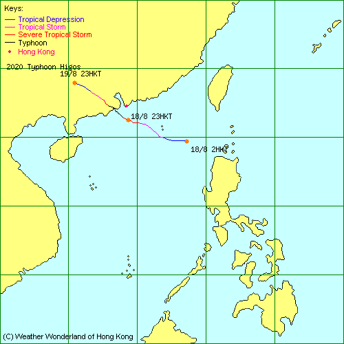
| 2020-08W | Higos | L.P. | HKO | Track Data | Weather Observation | Warnings |
| Track Map | ||||
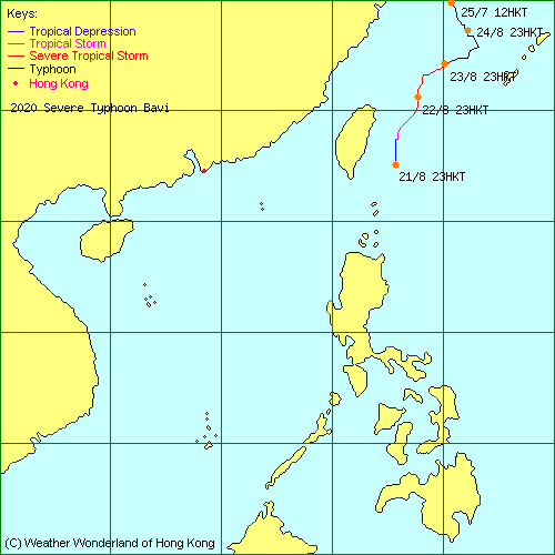
| 2020-09W | Bavi | L.P. | JTWC | Track Data | Track Map |
| 2020-10W | Maysak | L.P. | JTWC | Track Data |
| 2020-11W | Haishen | L.P. | JTWC | Track Data |
| 2020-12W | - | L.P. | JTWC | Track Data |
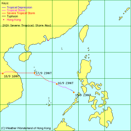
| 2020-13W | Noul | L.P. | HKO | Track Data | Track Map |
| 2020-14W | Dolphin | L.P. | JTWC | Track Data |
| 2020-15W | Kujira | L.P. | JTWC | Track Data |
| 2020-16W | Chan-hom | L.P. | JTWC | Track Data |
| 2020-17W | Linfa | L.P. | HKO | Track Data | Track Map |
| 2020-18W | Nangka | L.P. | HKO | Track Data | Weather Observation | Warnings |
| Track Map | ||||
| 2020-19W | Saudel | L.P. | HKO | Track Data | Weather Observation | Warnings |
| Track Map | ||||
| 2020-20W | - | L.P. | JTWC | Track Data |
| 2020-21W | Molave | L.P. | HKO | Track Data | Track Map |
| 2020-22W | Goni | L.P. | HKO | Track Data | Track Map |
| 2020-23W | Atsani | L.P. | HKO | Track Data | Track Map |
| 2020-24W | Etau | L.P. | HKO | Track Data | Track Map |
| 2020-25W | Vamco | L.P. | HKO | Track Data | Track Map |
| 2020-26W | Krovanh | L.P. | HKO | Track Data | Track Map |
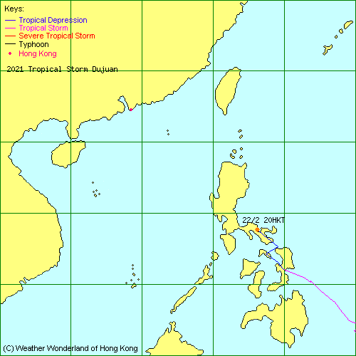
| 2021-01W | Dujuan | L.P. | HKO | Track Data | Track Map |
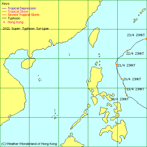
| 2021-02W | Surigae | L.P. | HKO | Track Data | Track Map |
| 2021-03W | - | L.P. | JTWC | Track Data |
| 2021-04W | Choi-wan | L.P. | JTWC | Track Data | Track Map |
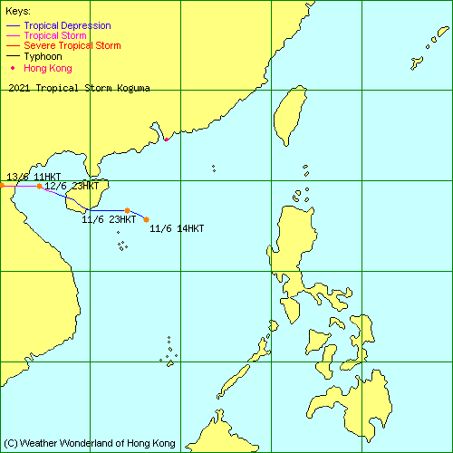
| 2021-05W | Koguma | L.P. | HKO | Track Data | Weather Observation | Warnings |
| Track Map | ||||
| 2021-06W | Champi | L.P. | JTWC | Track Data |
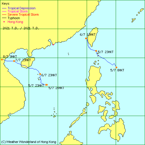
| 2021-07W | - | L.P. | HKO | Track Data | Weather Observation | Warnings |
| Track Map | ||||
| 2021-08W | - | L.P. | HKO | Track Data | Weather Observation | Warnings |
| Track Map | ||||
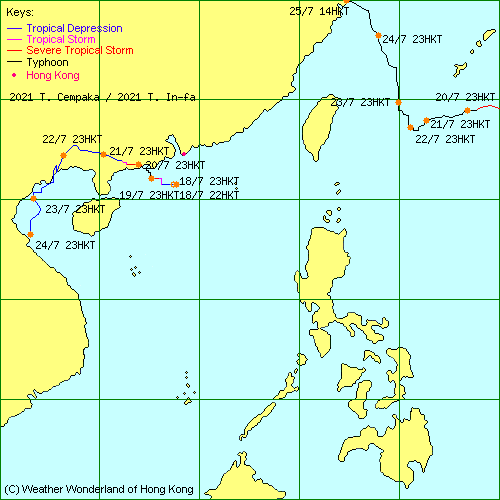
| 2021-09W | In-fa | L.P. | HKO | Track Data | Track Map |
| 2021-10W | Cempaka | L.P. | HKO | Track Data | Weather Observation | Warnings |
| Track Map | ||||
| 2021-11W | Nepartak | L.P. | JTWC | Track Data |
| 2021-12W | - | L.P. | JTWC | Track Data |
| 2021-13W | Lupit | L.P. | JTWC | Track Data | Weather Observation | Warnings |
| Track Map | ||||
| 2021-14W | Mirinae | L.P. | JTWC | Track Data |
| 2021-15W | Nida | L.P. | JTWC | Track Data |
| 2021-16W | Omais | L.P. | HKO | Track Data | Track Map |
| 2021-17W | - | L.P. | JTWC | Track Data |
| 2021-18W | Conson | L.P. | HKO | Track Data | Track Map |
| 2021-19W | Chanthu | L.P. | HKO | Track Data | Track Map |
| 2021-20W | Mindulle | L.P. | JTWC | Track Data |
| 2021-21W | Dianmu | L.P. | HKO | Track Data | Track Map |
| 2021-22W | Lionrock | L.P. | HKO | Track Data | Weather Observation | Warnings |
| Track Map | ||||
| 2021-23W | Namtheun | L.P. | JTWC | Track Data |
| 2021-24W | Kompasu | L.P. | HKO | Track Data | Weather Observation | Warnings |
| Track Map | ||||
| 2021-25W | Malou | L.P. | JTWC | Track Data |
| 2021-26W | - | L.P. | HKO | Track Data | Track Map |
| 2021-27W | Nyatoh | L.P. | JTWC | Track Data |
| 2021-28W | Rai | L.P. | HKO | Track Data | Weather Observation | Warnings |
| Track Map | ||||
| 2021-29W | - | L.P. | JTWC | Track Data |
| 2022-01W | - | L.P. | JTWC | Track Data |
| 2022-02W | Malakas | L.P. | JTWC | Track Data |
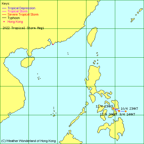
| 2022-03W | Megi | L.P. | HKO | Track Data | Track Map |
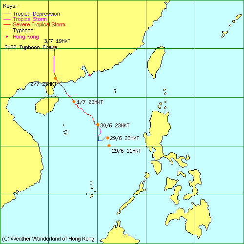
| 2022-04W | Chaba | L.P. | HKO | Track Data | Weather Observation | Warnings |
| Track Map | ||||
| 2022-05W | Aere | L.P. | JTWC | Track Data |
| 2022-06W | Songda | L.P. | HKO | Track Data |
| 2022-07W | Trases | L.P. | JTWC | Track Data |
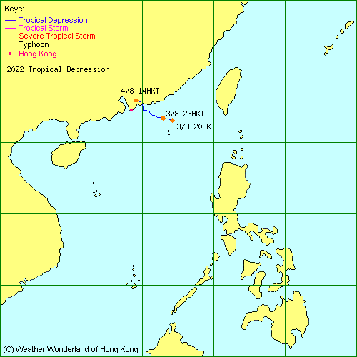
| 2022-08W | - | L.P. | HKO | Track Data | Weather Observation | Warnings |
| Track Map | ||||
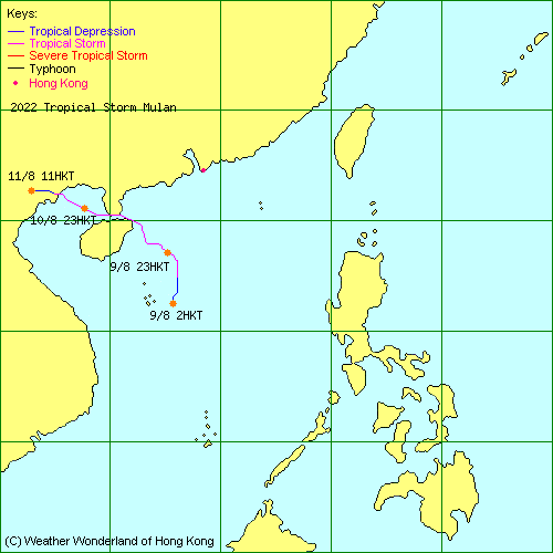
| - | Mulan | L.P. | HKO | Track Data | Weather Observation | Warnings |
| Track Map | ||||
| 2022-09W | Meari | L.P. | JTWC | Track Data |
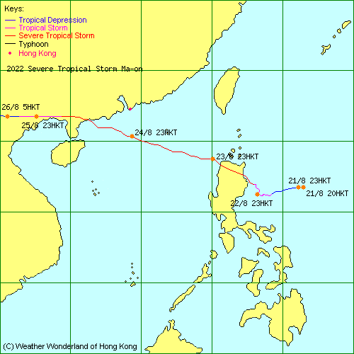
| 2022-10W | Ma-on | L.P. | HKO | Track Data | Weather Observation | Warnings |
| Track Map | ||||
| 2022-11W | Tokage | L.P. | JTWC | Track Data |
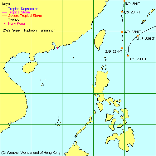
| 2022-12W | Hinnamnor | L.P. | JTWC | Track Data | Track Map |
| 2022-13W | - | L.P. | JTWC | Track Data |
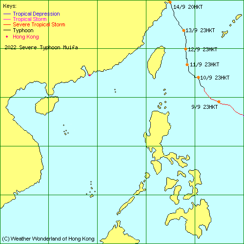
| 2022-14W | Muifa | L.P. | JTWC | Track Data | Track Map |
| 2022-15W | Merbok | L.P. | JTWC | Track Data |
| 2022-16W | Nanmadol | L.P. | JTWC | Track Data |
| 2022-17W | Talas | L.P. | HKO | Track Data |
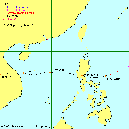
| 2022-18W | Noru | L.P. | HKO | Track Data | Track Map |
| 2022-19W | Kulap | L.P. | JTWC | Track Data |
| 2022-20W | Roke | L.P. | JTWC | Track Data |
| 2022-21W | - | L.P. | JTWC | Track Data |
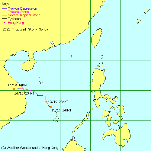
| 2022-22W | Sonca | L.P. | HKO | Track Data | Track Map |
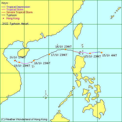
| 2022-23W | Nesat | L.P. | HKO | Track Data | Weather Observation | Warnings |
| Track Map | ||||
| 2022-24W | Haitang | L.P. | JTWC | Track Data |
| 2022-25W | - | L.P. | HKO | Track Data | Track Map |
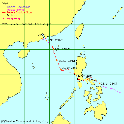
| 2022-26W | Nalgae | L.P. | HKO | Track Data | Weather Observation | Warnings |
| Track Map | ||||
| 2022-27W | Banyan | L.P. | JTWC | Track Data |
| 2022-28W | Yamaneko | L.P. | JTWC | Track Data |
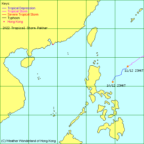
| 2022-29W | Pakhar | L.P. | HKO | Track Data | Track Map |
| - | - | L.P. | HKO | Track Data | Track Map |
| 2023-01W | Sanvu | L.P. | JTWC | Track Data |
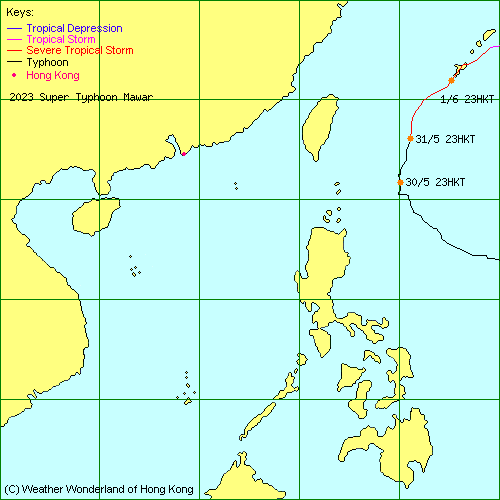
| 2023-02W | Mawar | L.P. | HKO | Track Data | Track Map |
| 2023-03W | Guchol | L.P. | HKO | Track Data |
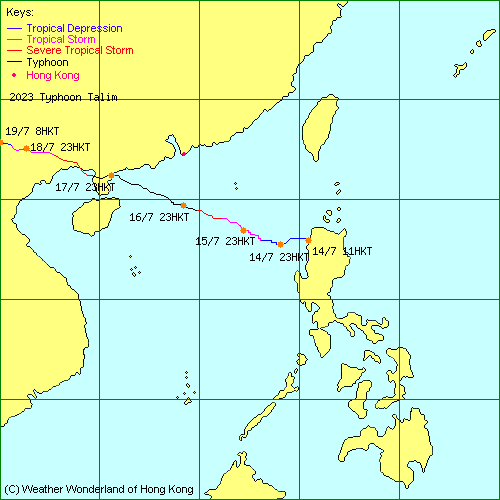
| 2023-04W | Talim | L.P. | HKO | Track Data | Weather Observation | Warnings |
| Track Map | ||||
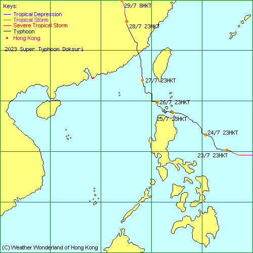
| 2023-05W | Doksuri | L.P. | HKO | Track Data | Weather Observation | Warnings |
| Track Map | ||||
| 2023-06W | Khanun | L.P. | JTWC | Track Data | Track Map |
| 2023-07W | Lan | L.P. | JTWC | Track Data |
| 2023-05E | Dora | L.P. | JTWC | Track Data |
| 2023-08W | Damrey | L.P. | JTWC | Track Data |
| 2023-09W | Saola | L.P. | HKO | Track Data | Weather Observation | Warnings |
| Track Map | ||||
| 2023-10W | Haikui | L.P. | HKO | Track Data | Weather Observation | Warnings |
| Track Map | ||||
| 2023-11W | Kirogi | L.P. | JTWC | Track Data |
| 2023-12W | Yun-yeung | L.P. | HKO | Track Data |
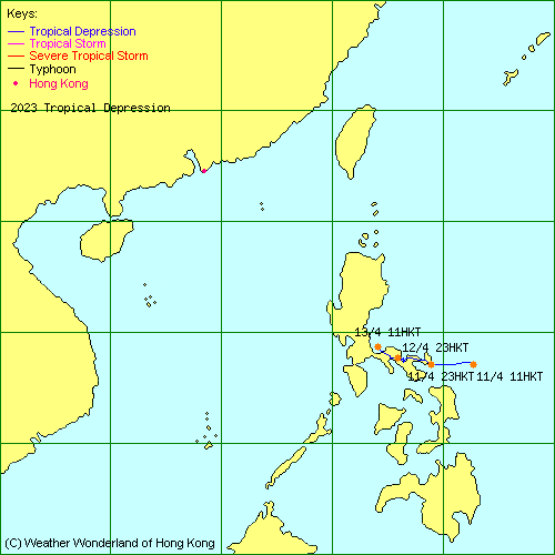
| 2023-13W | - | L.P. | HKO | Track Data | Track Map |
| 2023-13W | Koinu | L.P. | JTWC | Track Data | Weather Observation | Warnings |
| Track Map | ||||
| 2023-15W | Bolaven | L.P. | JTWC | Track Data |
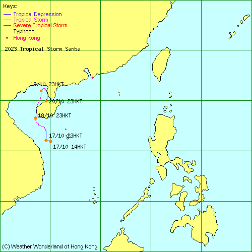
| 2023-16W | Sanba | L.P. | JTWC | Track Data | Track Map |
| 2023-17W | - | L.P. | JTWC | Track Data |
| 2023-18W | Jelawat | L.P. | HKO | Track Data |
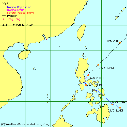
| 2024-01W | Ewiniar | L.P. | JTWC | Track Data | Track Map |
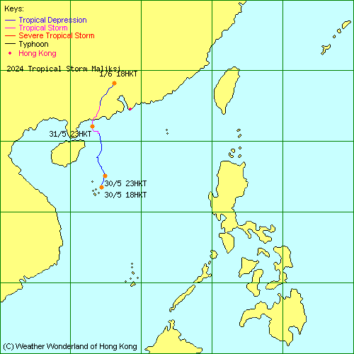
| 2024-02W | Maliksi | L.P. | HKO | Track Data | Weather Observation | Warnings |
| Track Map | ||||
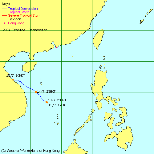
| 2024-03W | - | L.P. | HKO | Track Data | Track Map |
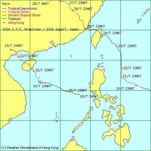
| 2024-04W | Prapiroon | L.P. | HKO | Track Data | Weather Observation | Warnings |
| Track Map | ||||
| 2024-05W | Gaemi | L.P. | HKO | Track Data | Track Map |
| 2024-06W | Maria | L.P. | JTWC | Track Data |
| 2024-07W | Son-tinh | L.P. | JTWC | Track Data |
| 2024-08W | Ampil | L.P. | JTWC | Track Data |
| 2024-09W | Wukong | L.P. | JTWC | Track Data |
| 2024-10W | Jongdari | L.P. | JTWC | Track Data |
| 2024-11W | Shanshan | L.P. | JTWC | Track Data |
| 2024-12W | Yagi | L.P. | HKO | Track Data | Weather Observation | Warnings |
| Track Map | ||||
| 2024-13W | Leepi | L.P. | JTWC | Track Data |
| 2024-14W | Bebinca | L.P. | HKO | Track Data |
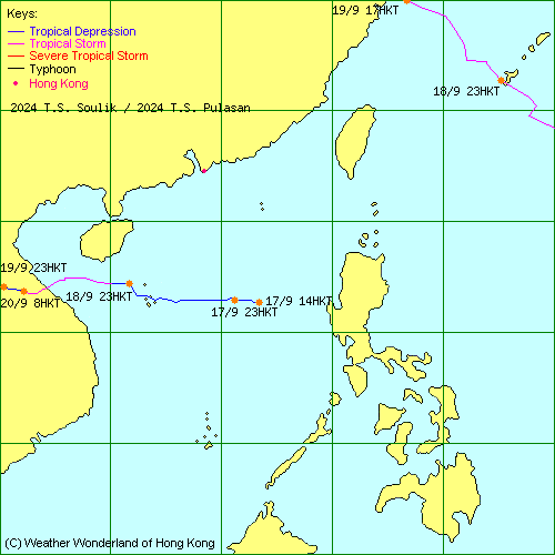
| 2024-15W | Pulasan | L.P. | JTWC | Track Data | Track Map |
| 2024-16W | Soulik | L.P. | HKO | Track Data | Track Map |
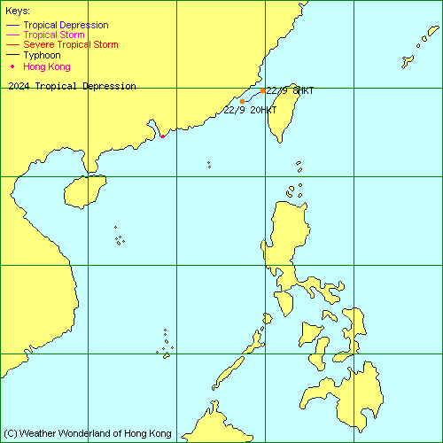
| 2024-17W | - | L.P. | HKO | Track Data | Track Map |
| 2024-18W | Cimaron | L.P. | JTWC | Track Data |
| 2024-19W | Jebi | L.P. | JTWC | Track Data |
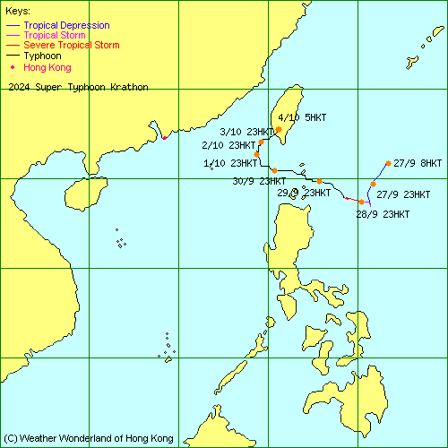
| 2024-20W | Krathon | L.P. | HKO | Track Data | Track Map |
| 2024-21W | Barijat | L.P. | JTWC | Track Data |
| 2024-22W | Trami | L.P. | JTWC | Track Data | Weather Observation | Warnings |
| Track Map | ||||
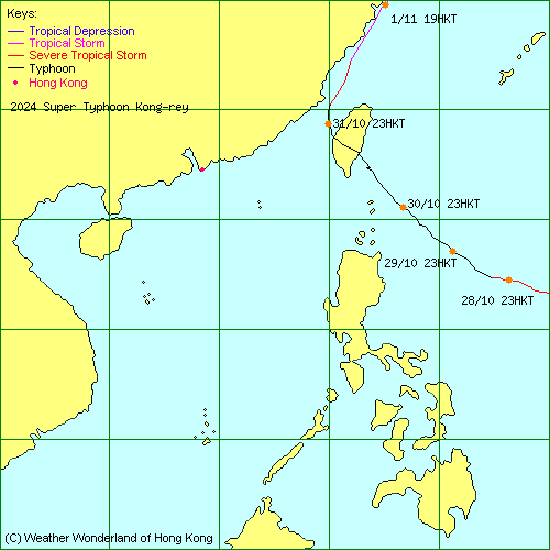
| 2024-23W | Kong-rey | L.P. | JTWC | Track Data | Track Map |
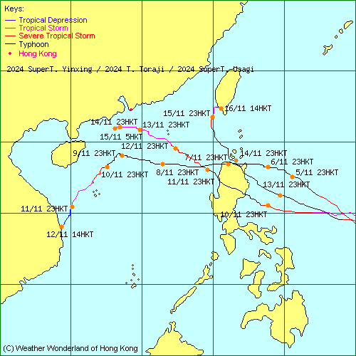
| 2024-24W | Yinxing | L.P. | JTWC | Track Data | Weather Observation | Warnings |
| Track Map | ||||
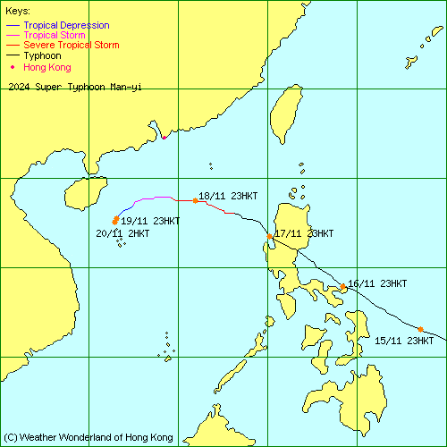
| 2024-25W | Man-yi | L.P. | HKO | Track Data | Weather Observation | Warnings |
| Track Map | ||||
| 2024-26W | Toraji | L.P. | HKO | Track Data | Weather Observation | Warnings |
| Track Map | ||||
| 2024-27W | Usagi | L.P. | JTWC | Track Data | Track Map |
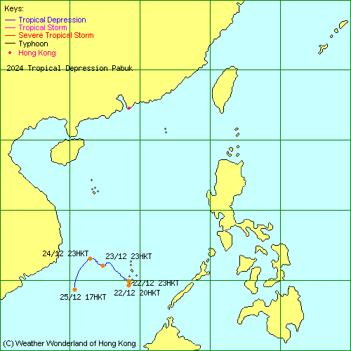
| 2024-28W | Pabuk | L.P. | HKO | Track Data | Track Map |
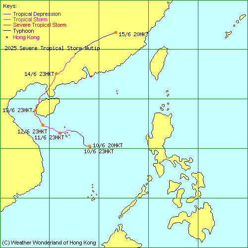
| 2025-01W | Wutip | L.P. | HKO | Track Data | Weather Observation | Warnings |
| Track Map | ||||
| 2025-02W | Sepat | L.P. | JTWC | Track Data |
| 2025-03W | - | L.P. | HKO | Track Data | Weather Observation | Warnings |
| Track Map | ||||
| 2025-04W | Mun | L.P. | JTWC | Track Data |
| 2025-05W | Danas | L.P. | HKO | Track Data | Weather Observation | Warnings |
| Track Map | ||||
| 2025-06W | Nari | L.P. | JTWC | Track Data |
| 2025-07W | - | L.P. | JTWC | Track Data |
| 2025-08W | - | L.P. | JTWC | Track Data |
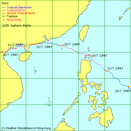
| 2025-09W | Wipha | L.P. | HKO | Track Data | Weather Observation | Warnings |
| Track Map | ||||
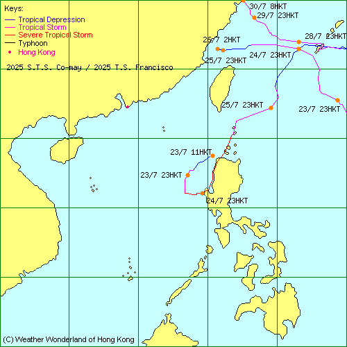
| 2025-10W | Francisco | L.P. | HKO | Track Data | Track Map |
| 2025-11W | Co-may | L.P. | HKO | Track Data | Track Map |
| 2025-12W | Krosa | L.P. | JTWC | Track Data |
| 2025-13W | Bailu | L.P. | JTWC | Track Data |
| 2025-01C | Iona | L.P. | JTWC | Track Data |
| 2025-14W | - | L.P. | JTWC | Track Data |
| 2025-15W | - | L.P. | JTWC | Track Data |
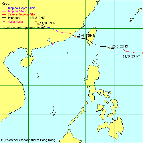
| 2025-16W | Podul | L.P. | HKO | Track Data | Weather Observation | Warnings |
| Track Map | ||||
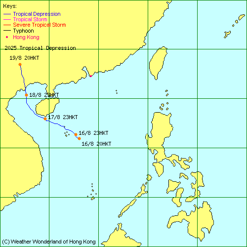
| 2025-17W | - | L.P. | HKO | Track Data | Weather Observation | Warnings |
| Track Map | ||||
| 2025-18W | Lingling | L.P. | HKO | Track Data |
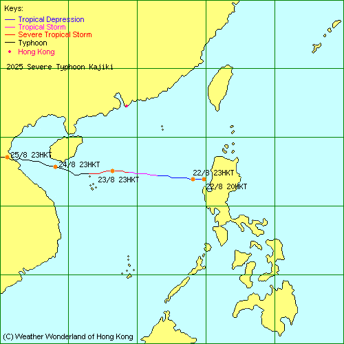
| 2025-19W | Kajiki | L.P. | HKO | Track Data | Weather Observation | Warnings |
| Track Map | ||||
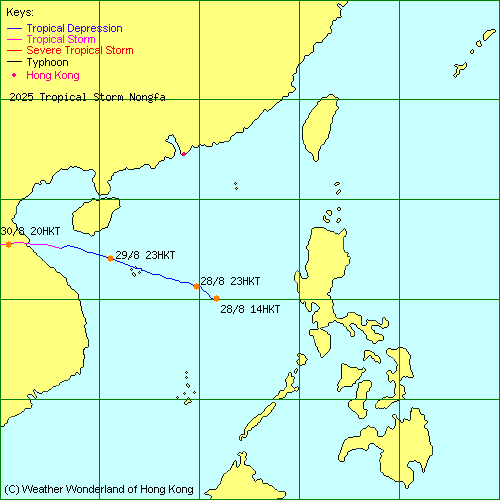
| 2025-20W | Nongfa | L.P. | HKO | Track Data | Weather Observation | Warnings |
| Track Map | ||||
| 2025-21W | Peipah | L.P. | JTWC | Track Data |
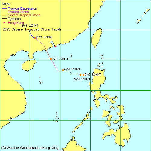
| 2025-22W | Tapah | L.P. | HKO | Track Data | Weather Observation | Warnings |
| Track Map | ||||
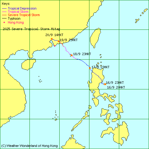
| 2025-23W | Mitag | L.P. | HKO | Track Data | Weather Observation | Warnings |
| Track Map | ||||
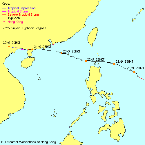
| 2025-24W | Ragasa | L.P. | HKO | Track Data | Weather Observation | Warnings |
| Track Map | ||||
| 2025-25W | Neoguri | L.P. | JTWC | Track Data |
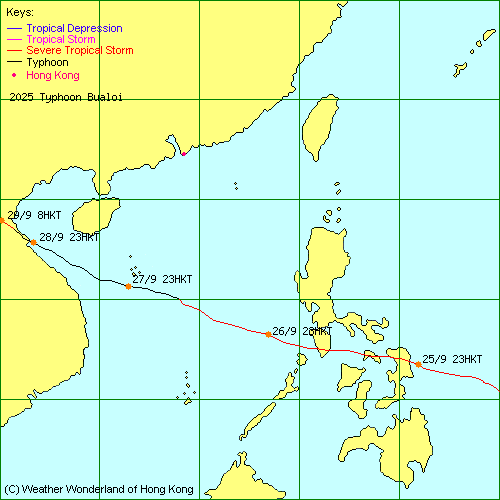
| 2025-26W | Bualoi | L.P. | HKO | Track Data | Track Map |
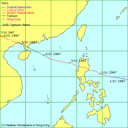
| 2025-27W | Matmo | L.P. | HKO | Track Data | Weather Observation | Warnings |
| Track Map | ||||
| 2025-28W | Halong | L.P. | JTWC | Track Data |
| 2025-29W | Nakri | L.P. | JTWC | Track Data |
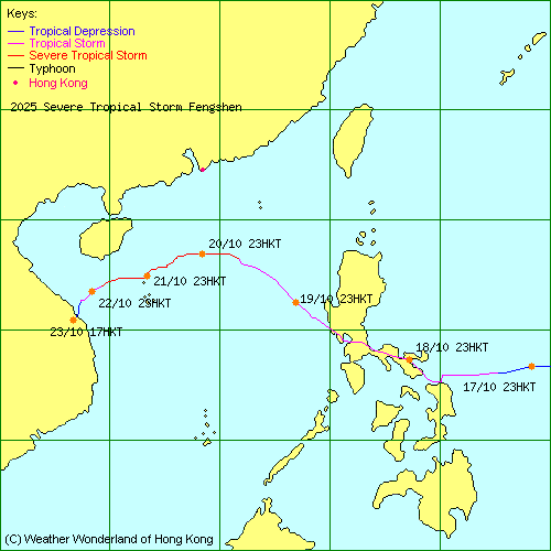
| 2025-30W | Fengshen | L.P. | HKO | Track Data | Weather Observation | Warnings |
| Track Map | ||||
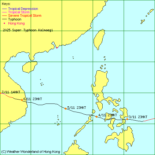
| 2025-31W | Kalmaegi | L.P. | HKO | Track Data | Track Map |
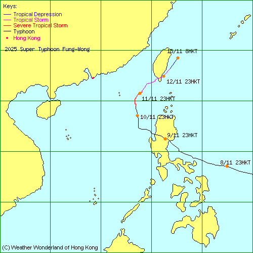
| 2025-32W | Fung-Wong | L.P. | JTWC | Track Data | Weather Observation | Warnings |
| Track Map | ||||
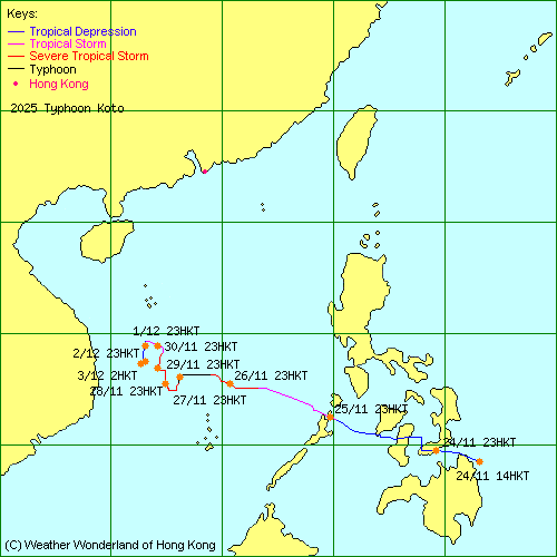
| 2025-33W | Koto | L.P. | HKO | Track Data | Track Map |
| 2025-34W | Senyar | L.P. | HKO | Track Data |
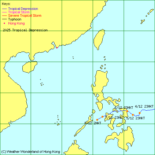
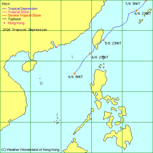
| - | - | L.P. | HKO | Track Data | Track Map |
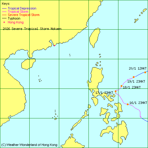
| 2026-01W | Nokaen | L.P. | HKO | Track Data | Track Map |
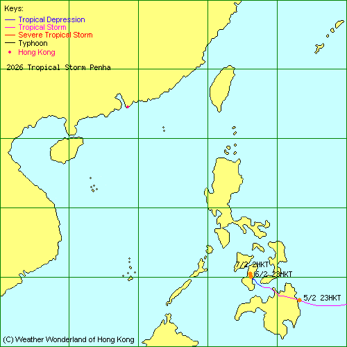
| 2026-02W | Penha | L.P. | HKO | Track Data | Track Map |
| 2026-03W | Nuri | L.P. | HKO | Track Data |
| 2026-04W | Sinlaku | L.P. | JTWC | Track Data |
| 2026-05W | Hagupit | L.P. | HKO | Track Data |
| 2026-06W | Jangmi | L.P. | JTWC | Track Data |
| - | - | L.P. | HKO | Track Data | Track Map |
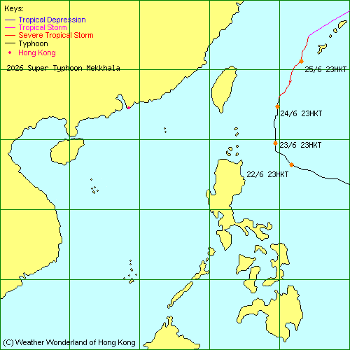
| 2026-07W | Mekkhala | L.P. | JTWC | Track Data | Track Map |
| 2026-08W | Higos | L.P. | HKO | Track Data |
| 2026-09W | Bavi | SuperT. | JTWC | Track Data |
| 2026-10W | Maysak | T.S. | HKO | Track Data | Weather Observation | Warnings |
Brief Message from Hong Kong Observatory: | ||||
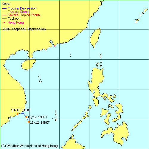
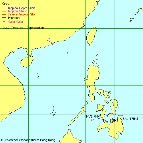
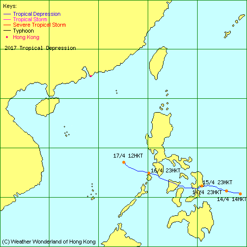
| The tracking map will be shown here when a tropical cyclone is centred within the region bounded by 5oN, 30oN, 105oE and 125oE. |
(The above tracking map is produced by the Weather Wonderland of Hong Kong.) |
|
|
|
|
| If you have any suggestions about this site, please kindly send an email to webmaster@weatherland.org.hk. |